Australia Services

Looks like you're in Australia

You've landed on our NZ website, click the link below to head to the Australian site.
Visit Australian Site
Stay on NZ website instead

Asset Management Digital Platforms

Capturing asset inspections in the field and keeping registers up to date doesn't have to be overwhelming.

Our team can integrate your existing systems into one accessible platform to streamline your data collection and assessment. Get ahead of asset management with the right toolset to help you go from reactive to proactive.
Heatmap imagery of an Auckland-based GIS tool for New Zealand councilsCouncil asset team member utilising a custom-built phone app by Morphum Environmental GIS team to log the asset conditions and manage their issuesData validation tool from multiple sources using the stormwater asset tracking system built for Auckland CouncilStormwater asset tracking geospatial system for councils across New Zealand to prioritise the upgrades renewals and maintenance of water networks
Asset Platforms ▸
Features ▸
Why Morphum ▸
Past Projects ▸
Related Services ▸
Contact Us ▸
Heatmap imagery of an Auckland-based GIS tool for New Zealand councils

Get Ahead Of Your Assets

With a full suite of tools to inspect, review, and prioritise key assets across your region, managing your infrastructure has never been more efficient.

Get ahead of issues with the right toolset to prioritise actions and streamline data collection with field apps, meaning you can spend less time managing data, and more time acting on it.
Talk to our GIS team ▸
Screenshot of a data health check tool for councils to assess their water network data in a concentrated location

One Tool To Manage All Your Assets

With custom tools to suit your specific requirements and workflows, you can plan and get ahead of future issues.

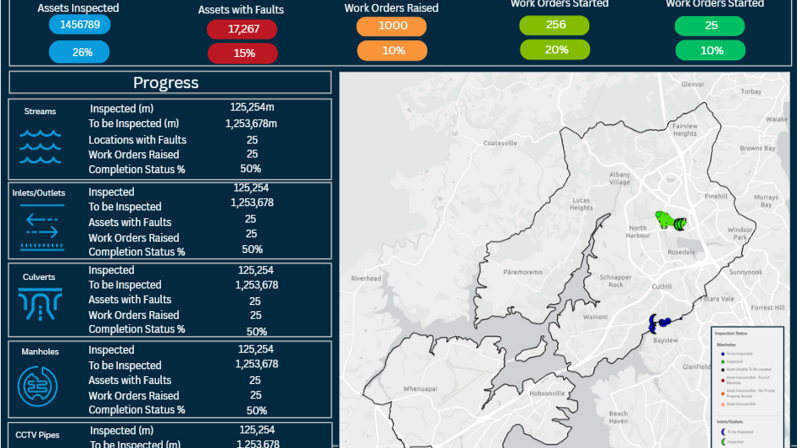
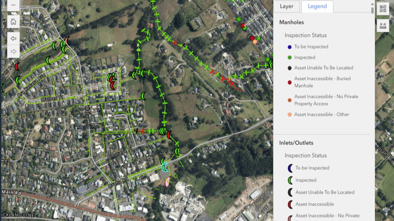
Your asset management platform can build on existing reactive workflows, creating one tool to manage the processes of all your infrastructure assets.
Council asset team member utilising a custom-built phone app by Morphum Environmental GIS team to log the asset conditions and manage their issues

Integrate Data Sources

Reduce the amount of time spent switching between different platforms.

Our team of data experts can integrate data in any format from any source into the platform, with full standardisation and quality assurance, providing one access point to all your data.
A stormwater asset manager assessing a stormwater outlet near the waikato river in New Zealand

Streamline Data Collection

Integrate data collected in the field with powerful data collection forms.

With an accompanying mobile app, your contractors and field workers can record data in the field, instantly updating the entire system in real-time.
Data validation tool from multiple sources using the stormwater asset tracking system built for Auckland Council

Prioritise Assets

Plan future maintenance, assessments and reaction procedures by prioritising assets in the platform.

Organise asset upgrades and renewals with the prioritisation and assessment options.
Reporting dashboard for stormwater management tracking systems for councils in new zealand

Reporting + Progress Updates

Easily export data and summaries from the platforms.

Using in-built dashboards, asset management platforms can provide updates on progress being made towards region-wide projects.
Talk to our GIS team ▸
Freshwater ecosystem with paradise shelduck, native forest, eels, inanga, dradonflies in a native stream with freshwater wetlands.

Why choose Morphum for your

Asset Management

Environmental Management System Services Icon

One Tool For All Your Data

With a single constructed location for all data analysis, our clients receive a fully integrated view of any geospatial mapping, visualisation and data that is collected.

Our suite of tools means that the pains and productivity delays of managing multiple data platforms are eliminated, leaving your team and stakeholders on the same page with the same data.
Environmental Management Plan Services Icon

Your Data, Your Tools

When a geospatial system is built, our clients may retain full ownership of their data and newly constructed geospatial toolkit, and we can provide training, architecture deployment and quality assurance to assist with the handover.

This means that they receive a custom built solution with an ongoing return that far outweighs the investment.
Catchment Planning Services

Experienced In Innovation

Since the development of modern geospatial mapping tools, Morphum has been continuously innovating new tools We first introduced these services nearly 20 years ago, and we continue to push the capabilities of GIS.

We've worked with clients across Aotearoa and Australia leading to cross-regional insights and an understanding of how we can create constant improvement to the geospatial services we offer.

Contact Us

Reach out to one of our engineers, scientists or sustainability specialists.

Email Us:

Our team will ensure your message reaches the right team member for you.
info@morphum.com

Phone Us:

You can reach our team by phone Monday - Friday during business hours
09 377 9779

Submit A Contact Form:

Our team will ensure your message makes it to the right team member for you. We aim to respond within 1-2 business days.
Thanks for reaching out! We will be in contact with you soon.
Error! Something went wrong while submitting the form. Please try again, or contact us with the details provided above.
Freshwater ecosystem with paradise shelduck, native forest, eels, inanga, dradonflies in a native stream with freshwater wetlands.
Call Now